You are moving to a new place in the United States and are in need of getting a new internet connection but not sure about who provides the best internet (better term may be ‘faster internet’) ?
No more worries, we now have a solution in the form of the ‘National Broadband Map’ here. It came from none other than the Federal Communications Commissions (FCC) of the Obama administration.
The National Broadband map for the United States (developed by the National Telecommunications and Information Administration) is a national broadband map containing data for thousands of broadband providers with more than 25 million searchable records and the results will be delivered in a map. You just have to key in your ZIP code or even street name along with ZIP code for even better localized result. The National Broadband map will then show you all the different Internet Service Providers along with the actual speeds that they are offering in your area.
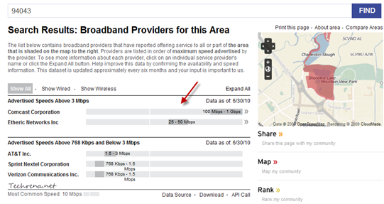
As you can in the screenshot above, I have around five different broadband providers to choose from for my query (ZIP Code 94043 in California) and you can see that Comcast is the fastest broadband provider in this area when compared to Etheric Networks (which is also offering decent speeds), AT&T, Verizon and Sprint. You can quickly get to know about availability of a particular ISP in your area (anywhere in the United States), or compare the available providers without needing to enter their websites or view the overall broadband connectivity map of the U.S.
Visit National Broadband Map
[via]

